Amazing Earth: Satellite Images From 2020
Amazing Earth: Satellite Images from 2020
In the vastness of the universe, the life-bringing beauty of our home planet shines bright. During this tumultuous year, our satellites captured some pockets of peace, while documenting data and striking visuals of unprecedented natural disasters. As 2020 comes to a close, we’re diving into some of the devastation, wonders, and anomalies this year had to offer.
NASA’s fleet of Earth-observing satellites and instruments on the International Space Station unravel the complexities of the blue marble from a cosmic vantage point. These robotic scientists orbit our globe constantly, monitoring and notating changes, providing crucial information to researchers here on the ground.
Take a glance at 2020 through the lens of NASA satellites:
A Delta Oasis in Southeastern Kazakhstan

Seen from space, the icy Ili River Delta contrasts sharply with the beige expansive deserts of southeastern Kazakhstan.
When the Operational Land Imager (OLI) on Landsat 8 acquired this natural-color image on March 7, 2020, the delta was just starting to shake off the chill of winter. While many of the delta’s lakes and ponds were still frozen, the ice on Lake Balkhash was breaking up, revealing swirls of sediment and the shallow, sandy bed of the western part of the lake.
The expansive delta and estuary is an oasis for life year round. Hundreds of plant and animal species call it home, including dozens that are threatened or endangered.
Fires and Smoke Engulf Southeastern Australia

A record-setting and deadly fire season marred the beginning of the year in Australia. Residents of the southeastern part of the country told news media about daytime seeming to turn to night, as thick smoke filled the skies and intense fires drove people from their homes.
This natural-color image of Southeastern Australia was acquired on January 4, 2020, by the Moderate Resolution Imaging Spectroradiometer (MODIS) on NASA’s Aqua satellite. The smoke has a tan color, while clouds are bright white. It is likely that some of the white patches above the smoke are pyrocumulonimbus clouds—clouds created by the convection and heat rising from a fire.
Nighttime Images Capture Change in China

A team of scientists from NASA’s Goddard Space Flight Center (GSFC) and Universities Space Research Association (USRA) detected signs of the shutdown of business and transportation around Hubei province in central China. As reported by the U.S. State Department, Chinese authorities suspended air, road, and rail travel in the area and placed restrictions on other activities in late January 2020 in response to the COVID-19 outbreak in the region.
A research team analyzed images of Earth at night to decipher patterns of energy use, transportation, migration, and other economic and social activities. Data for the images were acquired with the Visible Infrared Imaging Radiometer Suite (VIIRS) on the NOAA–NASA Suomi NPP satellite (launched in 2011) and processed by GSFC and USRA scientists. VIIRS has a low-light sensor—the day/night band—that measures light emissions and reflections. This capability has made it possible to distinguish the intensity, types, and sources of lights and to observe how they change.
The Parched Paraná River

Though a seemingly serene oasis from above, there is more to this scene than meets the eye. On July 3, 2020, the Operational Land Imager (OLI) on Landsat 8 captured this false-color image of the river near Rosario, a key port city in Argentina. The combination of shortwave infrared and visible light makes it easier to distinguish between land and water. A prolonged period of unusually warm weather and drought in southern Brazil, Paraguay, and northern Argentina dropped the Paraná River to its lowest water levels in decades. The parched river basin has hampered shipping and contributed to an increase in fire activity in the delta and floodplain.
The drought has affected the region since early 2020, and low water levels have grounded several ships, and many vessels have had to reduce their cargo in order to navigate the river. With Rosario serving as the distribution hub for much of Argentina’s soy and other farm exports, low water levels have caused hundreds of millions of dollars in losses for the grain sector, according to news reports.
Historic Fires Devastate the U.S. Pacific Coast

Climate and fire scientists have long anticipated that fires in the U.S. West would grow larger, more intense, and more dangerous. But even the most experienced among them have been at a loss for words in describing the scope and intensity of the fires burning in West Coast states during September 2020.
Lightning initially triggered many of the fires, but it was unusual and extreme meteorological conditions that turned some of them into the worst conflagrations in the region in decades.
Throughout the outbreak, sensors like the Visible Infrared Imaging Radiometer Suite (VIIRS) and the Ozone Mapping and Profiler Suite (OMPS) on the NOAA-NASA Suomi NPP satellite collected daily images showing expansive, thick plumes of aerosol particles blowing throughout the U.S. West on a scale that satellites and scientists rarely see.
This image shows North America on September 9th, 2020, as a frontal boundary moved into the Great Basin and produced very high downslope winds along the mountains of Washington, Oregon, and California. The winds whipped up the fires, while a pyrocumulus cloud from the Bear fire in California injected smoke high into the atmosphere. The sum of these events was an extremely thick blanket of smoke along the West Coast.
The Sandy Great Bahama Bank

Though the bright blues of island waters are appreciated by many from a sea-level view, their true beauty is revealed when photographed from space. The underwater masterpiece photographed above is composed of sand dunes off the coast of the Bahamas.
The Great Bahama Bank was dry land during past ice ages, but it slowly submerged as sea levels rose. Today, the bank is covered by water, though it can be as shallow as two meters (seven feet) deep in places. The wave-shaped ripples in the image are sand on the seafloor. The curves follow the slopes of the dunes, which were likely shaped by a fairly strong current near the sea bottom. Sand and seagrass are present in different quantities and depths, giving the image it’s striking range of blues and greens.
This image was captured on February 15th, 2020, by Landsat 8, whose predecessor, Landsat 7, was the first land-use satellite to take images over coastal waters and the open ocean. Today, many satellites and research programs map and monitor coral reef systems, and marine scientists have a consistent way to observe where the reefs are and how they are faring.
Painting Pennsylvania Hills

Along with the plentiful harvest of crops in North America, one of the gifts of Autumn is the gorgeous palette of colors created by the chemical transition and fall of leaves from deciduous trees.
The folded mountains of central Pennsylvania were past peak leaf-peeping season but still colorful when the Operational Land Imager (OLI) on the Landsat 8 satellite passed over on November 9, 2020. The natural-color image above shows the hilly region around State College, Pennsylvania overlaid on a digital elevation model to highlight the topography of the area.
The region of rolling hills and valleys is part of a geologic formation known as the Valley and Ridge Province that stretches from New York to Alabama. These prominent folds of rock were mostly raised up during several plate tectonic collisions and mountain-building episodes in the Ordovician Period and later in the creation of Pangea—when what is now North America was connected with Africa in a supercontinent. Those events created the long chain of the Appalachians, one of the oldest mountain ranges in the world.
A Dangerous Storm in the Night

Ominous and looming, a powerful storm hovered off the US coastline illuminated against the dark night hues.
The Visible Infrared Imaging Radiometer Suite (VIIRS) on NOAA-20 acquired this image of Hurricane Laura at 2:20 a.m. Central Daylight Time on August 26, 2020. Clouds are shown in infrared using brightness temperature data, which is useful for distinguishing cooler cloud structures from the warmer surface below. That data is overlaid on composite imagery of city lights from NASA’s Black Marble dataset.
Hurricane Laura was among the ten strongest hurricanes to ever make landfall in the United States. Forecasters had warned of a potentially devastating storm surge up to 20 feet along the coast, and the channel might have funneled that water far inland. It did not. The outcome was also a testament to strong forecasting and communication by the National Hurricane Center and local emergency management authorities in preparing the public for the hazards.
A Windbreak Grid in Hokkaido

From above, the Konsen Plateau in eastern Hokkaido offers a remarkable sight: a massive grid that spreads across the rural landscape like a checkerboard, visible even under a blanket of snow. Photographed by the Operational Land Imager (OLI) on Landsat 8, this man-made design is not only aesthetically pleasing, it’s also an agricultural insulator.
The strips are forested windbreaks—180-meter (590-foot) wide rows of coniferous trees that help shelter grasslands and animals from Hokkaido’s sometimes harsh weather. In addition to blocking winds and blowing snow during frigid, foggy winters, they help prevent winds from scattering soil and manure during the warmer months in this major dairy farming region of Japan.
Shadows from a Solar Eclipse

Formidable, rare, and awe-inspiring — the first and only total solar eclipse of 2020 occurred on December 14, with the path of totality stretching from the equatorial Pacific to the South Atlantic and passing through southern Argentina and Chile as shown in the lower half of the image above. The Advanced Baseline Imager (ABI) on Geostationary Operational Environmental Satellite 16 (GOES-16) captured these images of the Moon’s shadow crossing the face of Earth.
The “path of totality” (umbral path) for the eclipse was roughly 90 kilometers (60 miles) wide and passed across South America from Saavedra, Chile, to Salina del Eje, Argentina. While a total eclipse of the Sun occurs roughly every 18 months, seeing one from any particular location on Earth is rare. On average, a solar eclipse passes over the same parcel of land roughly every 375 years. The next total solar eclipse will occur on December 4, 2021 over Antarctica, and its next appearance over North America is projected for April 8, 2024.
For additional information and a look at more images like these visit NASA’s Earth Observatory.
Make sure to follow us on Tumblr for your regular dose of space: http://nasa.tumblr.com.
More Posts from Nasa and Others
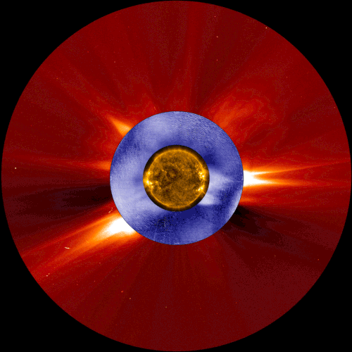
This composite image shows a coronal mass ejection, a type of space weather linked to solar energetic particles, as seen from two space-based solar observatories and one ground-based instrument. The image in gold is from NASA’s Solar Dynamics Observatory, the image in blue is from the Manua Loa Solar Observatory’s K-Cor coronagraph, and the image in red is from ESA and NASA’s Solar and Heliospheric Observatory.
Our constantly-changing sun sometimes erupts with bursts of light, solar material, or ultra-fast energized particles — collectively, these events contribute to space weather. A new study shows that the warning signs of one type of space weather event can be detected tens of minutes earlier than with current forecasting techniques – critical extra time that could help protect astronauts in space.
Credits: NASA/ESA/SOHO/SDO/Joy Ng and MLSO/K-Cor
7 Facts That Will Make You Feel Very Small
Earth, our home planet, is the fifth largest planet in our solar system and the only planet we know of where life exists. Even though Earth seems extremely large to us, it is actually a tiny spec in the vast expanse of the universe. Here are 7 space facts that will make you feel very small.

1. Our sun is one of at least 100 BILLION stars, just in the Milky Way. Scientists calculate that there are at least 100 billion galaxies in the observable universe, each one brimming with stars. There are more stars than grains of sand on all of Earth’s beaches combined.
In 1995, the first planet beyond our solar system was discovered. Now, thousands of planets orbiting sun-like stars have been discovered, also known as exoplanets.

2. The Milky Way is a huge city of stars, so big that even at the speed of light (which is fast!), it would take 100,000 years to travel across it.

3. Roughly 70% of the universe is made of dark energy. Dark matter makes up about 25%. The rest — everything on Earth, everything ever observed with all of our instruments, all normal matter adds up to less than 5% of the universe.

4. If the sun were as tall as a typical front door, Earth would be the size of a nickel.

5. The sun accounts for almost all of the mass in our solar system. Leaving .2% for all the planets and everything else.

6. Edwin Hubble discovered that the Universe is expanding and that at one point in time (14 billion years ago) the universe was all collected in just one point of space.

7. Four American spacecraft are headed out of our solar system to what scientists call interstellar space. Voyager 1 is the farthest out — more than 11 billion miles from our sun. It was the first manmade object to leave our solar system. Voyager 2, is speeding along at more than 39,000 mph, but will still take more than 296,000 years to pass Sirius, the brightest star in our night sky.
Feeling small yet? Here’s a tool that will show you just how tiny we are compared to everything else out there: http://imagine.gsfc.nasa.gov/features/cosmic/earth.html
Make sure to follow us on Tumblr for your regular dose of space: http://nasa.tumblr.com
Chart-Topping Space Images From 2019 You Won’t Want to Miss
From the first-ever image of a black hole, to astronaut Christina Koch breaking the record for the longest single spaceflight by a woman – 2019 was full of awe-inspiring events!
As we look forward to a new decade, we’ve taken ten of our top Instagram posts and put them here for your viewing pleasure. With eight out of ten being carousels, be sure to click on each title to navigate to the full post.
1. First-Ever Black Hole Image Makes History

In a historic feat by the Event horizon Telescope and National Science Foundation, an image of a black hole and its shadow was captured for the first time. At a whopping 3.4 million likes, this image takes home the gold as our most loved photo of 2019. Several of our missions were part of a large effort to observe this black hole using different wavelengths of light and collect data to understand its environment. Here’s a look at our Chandra X-Ray Observatory’s close-up of the core of the M87 galaxy with the imaged black hole at its center.
2. Hubble Celebrates 29 Years of Dazzling Discoveries


When you wish upon a star… Hubble captures it from afar ✨On April 18, 2019 our Hubble Space Telescope celebrated 29 years of dazzling discoveries, serving as a window to the wonders of worlds light-years away.
Hubble continues to observe the universe in near-ultraviolet, visible, and near-infrared light. Over the past 29 years, it has captured the farthest views ever taken of the evolving universe, found planet-forming disks around nearby stars and identified the first supermassive black hole in the heart of a neighboring galaxy. Want more? Enjoy the full 10 photo Instagram carousel here.
3. Stars and Stripes in Space for Flag Day


Patriotism was in the air June 14 for Flag Day, and coming in at number three in our most liked Instagram line up is a carousel of our stars and stripes in space! One of the most iconic images from the Apollo 11 missions is of Buzz Aldrin saluting the American flag on the surface of the Moon. But did you know that over the years, five more flags joined the one left by Apollo 11 – and that many other flags have flown onboard our spacecraft? Scroll through the full carousel for flag day here.
4. Spitzer Celebrates its Super Sweet 16!


Since 2003, our Spitzer Space Telescope has been lifting the veil on the wonders of the cosmos, from our own solar system to faraway galaxies, using infrared light! Thanks to Spitzer, we've confirm the presence of seven rocky, Earth-size planets, received weather maps of hot, gaseous exoplanets and discovered a hidden ring around Saturn. In honor of Spitzer's Sweet 16 in space, enjoy 16 jaw-dropping images from its mission here.
5. Earth as Seen Through Our Astronauts’ Eyes Show Perspective Changing Views

“That's here. That's home. That's us.” – Carl Sagan
Seeing Earth from space can alter an astronauts’ cosmic perspective, a mental shift known as the “Overview Effect.” First coined by space writer Frank White in 1987, the Overview Effect is described as a feeling of awe for our home planet and a sense of responsibility for taking care of it. See Earth from the vantage point of our astronauts in a carousel of perspective-changing views here.
6. Astronaut Christina Koch Breaks Record for Longest Single Spaceflight by Woman


Astronaut Christina Koch (@Astro_Christina) set a record Dec. 28, 2019 for the longest single spaceflight by a woman, eclipsing the former record of 288 days set by Peggy Whitson. Her long-duration mission is helping us learn how to keep astronauts healthy for deep space exploration to the Moon and Mars. Congrats to Christina on reaching new heights! Join in the celebration and view few photos she captured from her vantage point aboard the Space Station here.
7. Our Beautiful Planet – The Only Place We Know to Harbor Life – From Space


Earth is special. It’s the only place in the universe that we know contains life.
On July 7, 2019, two million people joined us in celebrating its beauty with a jaw dropping carousel of our home planet, as captured by crew members aboard the International Space Station. Bright blue oceans, glowing city lights and ice-capped mountain peaks come to life in a collection of breathtaking images, found here.
8. A Moon Even Sinatra Couldn’t Help But Sing About

Every 29 days our Moon turns over a new leaf, and on May, 18 we saw a very special one of its faces. Appearing opposite the Sun at 5:11 p.m. EDT, the world looked up to find a Blue Moon! Though the Moon didn’t actually look blue, the site of one is kind of rare. They occur on average about every two-and-a-half years when a season ends up having four full moons instead of three. Click through a carousel of high-definition lunar phases here.
9. The Majesty of Hubble Imagery ... From Your Backyard


On December 23, a new gallery of Hubble Space Telescope images highlighting celestial objects visible to amateur and professional astronomers alike was released. All of the objects are from a collection known as the Caldwell catalog, which includes 109 interesting objects visible in amateur-sized telescopes in both the northern and southern skies. Flip through the jaw-dropping carousel here, and learn more about how you can study the night sky with Hubble here.
10. The Moon Gets Sassy

Nobody:
The Moon: “Y'all on the way yet?” 👀
We're working on it, Moon. Under the Artemis program, we're sending the first woman and the next man to walk on your surface by 2024. Find out how we’re doing it here.

For more pictures like these, follow us on Instagram: https://www.instagram.com/nasa/
Make sure to follow us on Tumblr for your regular dose of space: http://nasa.tumblr.com

Thanks for all of the great questions! Follow me at @Astro_Jeanette on Twitter and @Jeanette.Epps on Instagram, and follow the International Space Station on Twitter, Facebook, and Instagram as I prepare for my mission next year.
9 Ocean Facts You Likely Don’t Know, but Should
Earth is a place dominated by water, mainly oceans. It’s also a place our researchers study to understand life. Trillions of gallons of water flow freely across the surface of our blue-green planet. Ocean’s vibrant ecosystems impact our lives in many ways.
In celebration of World Oceans Day, here are a few things you might not know about these complex waterways.
1. Why is the ocean blue?

The way light is absorbed and scattered throughout the ocean determines which colors it takes on. Red, orange, yellow,and green light are absorbed quickly beneath the surface, leaving blue light to be scattered and reflected back. This causes us to see various blue and violet hues.
2. Want a good fishing spot?

Follow the phytoplankton! These small plant-like organisms are the beginning of the food web for most of the ocean. As phytoplankton grow and multiply, they are eaten by zooplankton, small fish and other animals. Larger animals then eat the smaller ones. The fishing industry identifies good spots by using ocean color images to locate areas rich in phytoplankton. Phytoplankton, as revealed by ocean color, frequently show scientists where ocean currents provide nutrients for plant growth.
3. The ocean is many colors.

When we look at the ocean from space, we see many different shades of blue. Using instruments that are more sensitive than the human eye, we can measure carefully the fantastic array of colors of the ocean. Different colors may reveal the presence and amount of phytoplankton, sediments and dissolved organic matter.
4. The ocean can be a dark place.
About 70 percent of the planet is ocean, with an average depth of more than 12,400 feet. Given that light doesn’t penetrate much deeper than 330 feet below the water’s surface (in the clearest water), most of our planet is in a perpetual state of darkness. Although dark, this part of the ocean still supports many forms of life, some of which are fed by sinking phytoplankton.
5. We study all aspects of ocean life.

Instruments on satellites in space, hundreds of kilometers above us, can measure many things about the sea: surface winds, sea surface temperature, water color, wave height, and height of the ocean surface.
6. In a gallon of average sea water, there is about 1/2 cup of salt.

The amount of salt varies depending on location. The Atlantic Ocean is saltier than the Pacific Ocean, for instance. Most of the salt in the ocean is the same kind of salt we put on our food: sodium chloride.
7. A single drop of sea water is teeming with life.

It will most likely have millions (yes, millions!) of bacteria and viruses, thousands of phytoplankton cells, and even some fish eggs, baby crabs, and small worms.
8. Where does Earth store freshwater?

Just 3.5 percent of Earth’s water is fresh—that is, with few salts in it. You can find Earth’s freshwater in our lakes, rivers, and streams, but don’t forget groundwater and glaciers. Over 68 percent of Earth’s freshwater is locked up in ice and glaciers. And another 30 percent is in groundwater.
9. Phytoplankton are the “lungs of the ocean”.

Just like forests are considered the “lungs of the earth”, phytoplankton is known for providing the same service in the ocean! They consume carbon dioxide, dissolved in the sunlit portion of the ocean, and produce about half of the world’s oxygen.
Want to learn more about how we study the ocean? Follow @NASAEarth on twitter.
Make sure to follow us on Tumblr for your regular dose of space: http://nasa.tumblr.com.
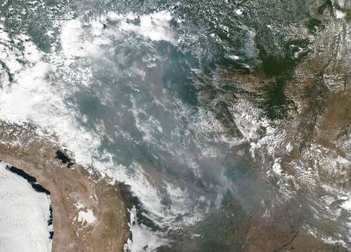
Fires in the Amazon Rainforest
This natural-color image shows smoke from fires in the Amazon rainforest spreading across several states within Brazil, including Amazonas, Mato Grosso, and Rondônia. The image was collected by our VIIRS (Visible Infrared Imaging Radiometer Suite) instrument aboard the Suomi NPP satellite (a joint-partnership between NASA and the National Oceanic and Atmospheric Administration) on August 20, 2019. It’s not unusual to see fires in Brazil at this time of year, but activity in the country’s largest state, Amazonas, has been above average. Many people use fire to maintain farmland and pastures or to clear land for other purposes.
Credits: NASA Worldview, Earth Observing System Data and Information System (EOSDIS).
Make sure to follow us on Tumblr for your regular dose of space: http://nasa.tumblr.com.
Dr. Beach’s Top 10 Beaches of 2021
For more than 30 years, Dr. Beach, aka Dr. Stephen Leatherman, has created an annual Top 10 Beach list. A professor and coastal geomorphologist at Florida International University, Dr. Beach factors in 50 different criteria including water color, sand softness, wave size, water temperature and more.
As we get ready to launch Landsat 9 this fall, we’re taking a tour of Dr. Beach’s Top 10 US beaches of 2021 as seen by Landsat 8.
10. Coast Guard Beach, Cape Cod, Massachusetts

Coast Guard Beach is located just north of the remote Nauset Inlet on Outer Cape Cod, Massachusetts. Except for the picturesque old white Coast Guard station that still sits atop the glacial bluffs, there is no development here; the best way to reach this beach is by bicycle from the Salt Pond Visitor’s Center or shuttle bus.
First mapped by Champlain in 1605, the shifting sands of this inlet are clearly visible in the Landsat image. This location is also at the point where the glacial sea cliffs transcend into a barrier beach (e.g., sand spit) that provides protection for the lagoon and development of lush salt marshes.
“In my early days as a Professor at Boston University and later at the University of Massachusetts at Amherst, I spent many summer and some winter-time days conducting scientific studies along this barrier beach.” – Dr. Beach
Landsat 8 collected this image of Coast Guard Beach on May 1, 2021.
9. Beachwalker Park, Kiawah Island, South Carolina

Beachwalker Park is a public beach located on the southern part of Kiawah Island, South Carolina. This barrier island in the Charleston area is 10-miles long and features a fine grained, hard-packed beach that can be traversed easily by bicycle.
This Landsat image shows a huge accumulation of sand as a series of shoals on the south end of the island, which can be reached from Beachwalker Park. These sandy shoals will eventually coalesce, becoming an extension of the sand spit that is the south end of Kiawah Island.
“In the early 2000s, I served as the beach consultant to the Town of Kiawah Island because their world-famous golf course on the north end was being threatened by severe erosion. It was necessary to artificially bypass some sand on the north end of the island so that the normal flow of sand along the island was reinstated, saving the outermost link of this PGA golf course.” – Dr. Beach
Landsat 8 collected this image of Beachwalker Park on April 9, 2021.
8. Coronado Beach, San Diego, California

Coronado Beach in San Diego is the toast of Southern California with some of the warmest and safest water on the Pacific coast. This 100-meter-wide beach is an oasis of subtropical vegetation, unique Mediterranean climate, and fine sparkling sand.
The harbor serves as a major port for the Navy’s Pacific fleet, the home port for several aircraft carriers. The docks and the crossing airplane runways for the Naval base are visible in this Landsat image.
“I really enjoy visiting this beautiful beach as well as having lunch and drinks, taking advantage of the hotel’s beachside service.” – Dr. Beach
Landsat 8 collected this image of Coronado Beach on April 23, 2020.
7. Caladesi Island State Park, Dunedin Clearwater, Florida

Caladesi Island State Park is located in the small town of Dunedin on the Southwest Florida coast. The stark white undeveloped beach is composed of crystalline quartz sand which is soft and cushy at the water’s edge, inviting one to take a dip in the sparkling clear waters.
While island is still in the Park’s name, Caladesi is no longer a true island as shown on the Landsat image--it is now connected to Clearwater Beach.
“Caladesi is located in the Tampa area, but it seems like a world away on this getaway island.” – Dr. Beach
Landsat 8 collected this image of Caladesi Island State Park on April 9, 2021.
6. Duke Kahanamoku Beach, Oahu, Hawaii

Duke Kahanamoku Beach is named for the famous native Hawaiian who was a big-board surfer and introduced surfing as a sport to mainland Americans and indeed the world.
One of the prominent features on this Landsat image is Diamondhead with its circular shape near the coast. This large cone of an extinct volcano provides the iconic backdrop for photos of Waikiki Beach.
“This is my favorite spot at the world-famous Waikiki Beach where you can both play in the surf and swim in the calm lagoonal waters.” – Dr. Beach
Landsat 8 collected this image of Duke Kahanamoku Beach on May 17, 2020.
5. Lighthouse Beach, Buxton, Outer Banks of North Carolina

Lighthouse Beach in the village of Buxton is located at Cape Hatteras, the most northern cape in the Outer Banks of North Carolina. This lifeguarded beach is the number one surfing spot on the US Atlantic Coast as the large offshore sand banks, known as Diamond Shoals, cause wave refraction focusing wave energy on this beach.
The Landsat image shows the seaward growth of south flank of Cape Hatteras as evidenced by the parallel lines of beach ridges.
“It is fun to walk down the narrow sand spit, more exposed at low tide, as waves are approaching from both directions because of the bending of the waves.” – Dr. Beach
Landsat 8 collected this image of Lighthouse Beach on May 3, 2020.
4. St. George Island State Park, Florida Panhandle

St. George Island State Park, located on the Florida panhandle and far from urban areas, is a favorite destination for beachgoers, anglers and bird watchers as nature abounds. Like other beaches on the panhandle, this long barrier island has a sugary fine, white sand beach.
In this Landsat image, St. George can be seen north of the bridge that links this barrier island to the mainland. The enclosed bay behind St. George Island is fairly shallow and the water much less clear as shown on the Landsat image, but it is not polluted.
“Besides swimming in the crystal-clear Gulf of Mexico waters, I enjoy beachcombing and shelling. While this island was hit hard in 2018 by Hurricane Michael, it has substantially recovered as there was little development to be impacted.” – Dr. Beach
Landsat 8 collected this image of St. George Island State Park on October 13, 2020.
3. Ocracoke Lifeguard Beach, Outer Banks of North Carolina

Ocracoke Lifeguarded Beach at the southern end of Cape Hatteras National Seashore was the first seashore to be incorporated into the National Park Service system.
The Landsat image shows Ocracoke to the north as separated by an inlet from Portsmouth Island. The village of Ocracoke was built at the wide area of the island where it was protected from oceanic waves during coastal storms which include both winter nor’easters and hurricanes.
“Ocracoke was once the home of the most infamous pirate Blackbeard and is still a very special place—my favorite getaway beach.” – Dr. Beach
Landsat 8 collected this image of Ocracoke Lifeguard Beach on May 3, 2020.
2. Cooper’s Beach, Southampton, New York

Cooper’s Beach in the tony town of Southampton on the south shore of Long Island, New York is shielded from the cold Labrador current, making for a fairly long summer swimming season. The white quartz sand is medium to coarse grained with some pebbles, making the beach slope fairly steeply into the water.
This Landsat image shows the fairly large coastal pond named Mecox Bay to the east with Shinnecock Inlet and Bay also displayed to the west. Coopers Beach is hundreds of yards wide, made of grainy white quartz sand and is backed by large sand dunes covered by American beach grass.
“I spent several decades conducting scientific studies of this very interest oceanic shoreline because it is so dynamic and the beachfront real estate so expensive. Some of the most gorgeous and expensive residential houses in the United States are located in the world-famous Hamptons.” – Dr. Beach
Landsat 8 collected this image of Coopers Beach on August 30, 2019.
1. Hapuna Beach State Park, Big Island Hawaii

Hapuna Beach State Park is a white coral sand beach that resides in a landscape dominated by dark brown lava flows on the Big Island of Hawaii. The crystal-clear water is perfect for swimming, snorkeling, and scuba diving during the summer months in contrast to winter big-wave days when pounding shorebreaks and rip currents make swimming impossible.
Hapuna and the other pocket beaches appear as an oasis in this otherwise fairly bleak landscape except for the areas irrigated as prominently shown on the Landsat imagery by the green vegetation.
“This volcanically active island is the only place that I know where you can snow ski at the high mountain tops and water ski in the warm ocean water on the same day.” – Dr. Beach
Landsat 8 collected this image of Hapuna State Park on January 5, 2021.
What’s your favorite beach?
View Dr. Beach’s 2021 picks and see Landsat views of these beaches over time.
Make sure to follow us on Tumblr for your regular dose of space!
#YearInSpace Reddit AMA
NASA astronaut Scott Kelly and Russian cosmonaut Mikhail Kornienko will return from a year-long mission to the International Space Station on Tuesday, March 1. Research conducted during this mission will help prepare us for future voyages beyond low-Earth orbit.

On Friday, March 4 at 11 a.m. EST, we will host a Reddit AMA with scientists and medical doctors from our Johnson Space Center. During the AMA, they will answer your questions about everything from how microgravity affects the human body to how astronauts’ food intake is closely monitored while on-orbit. Ask us anything about the science behind the One Year Mission!
Participants include:
Julie Robinson, Ph.D., NASA’s Chief Scientist for the International Space Station
John Charles, Ph.D., Associate Manager for International Science for NASA’s Human Research Program
Scott M. Smith, Ph.D., Nutritional Biochemistry Laboratory Manager for NASA’s Human Research Program
Dr. Shannan Moynihan, NASA Flight Surgeon
Bruce Nieschwitz, Strength and Conditioning Coach
Join us on Reddit here
Make sure to follow us on Tumblr for your regular dose of space: http://nasa.tumblr.com
Great Scott, it’s Back to the Future Day – Oct. 21, 2015
What would a time traveler from 1985 discover about NASA today?
It’s Back to the Future Day, the date in the second film that Marty and Doc traveled to in the future. When they arrived in 2015, it looked much different than today’s reality. Although we may not have self-drying jackets or flying cars, we do have some amazing spacecraft and technologies that were not around back when the film was made.

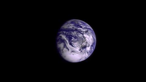
For example, in 1985 we did not have the capability to capture an image like this of our Earth. This full-Earth view captured Monday (10/19/15) by our camera on the Deep Space Climate Observatory, or DSCOVER, was not previously possible. The DSCOVR mission captures a daily sequence of images that show the Earth as it rotates, revealing the whole globe over the course of a day. These images will allow scientists to study daily variations over the entire globe in such features as vegetation, ozone, aerosols and cloud height and reflectivity.
So, we might not be cruising down the street on hover boards, but the movies didn’t get it all wrong in terms of how advanced we’d be in 2015.
When you were a kid, what technologies did you dream we’d have in the future that we may or may not have today? Here’s what two astronauts said:
NASA is much different than it was in 1985. Could we have dreamed these amazing accomplishments that have changed our world and understanding of the universe?
1. “There will be an orbiting laboratory where astronauts from around the world will live and work together.”

When Back to the Future II was set, the International Space Station didn’t exist yet. The first piece of the space station was launched in 1998, and the first crew arrived in 2000. Since November 2000, the station has been continuously occupied by humans.
2. "We will find planets orbiting in the habitable zone of a star, and possibly suited for life."

The first exoplanet, or planet orbiting around a star, was found in 1995. Since then, we’ve discovered around a dozen habitable zone planets in the Earth-size range. While we aren’t able to zoom in to these planets that are light-years away, we’re still closer to finding another Earth-like planet in 2015 than we were in 1985.
3. “Mars will become more populated.”

No, not by humans...yet. But, since the release of Back to the Future II, Mars has become a bit more populated with rovers and orbiters. These scientific spacecraft have played an important role in learning about the Red Planet. We currently have six missions at Mars. With the most recent news of liquid water on the surface of Mars, we can look forward to future missions returning even more data and images. The historical log of all Mars missions, both domestic and international can be found HERE.
4. “We will launch a telescope into orbit that’s capable of looking at locations more than 13.4 billion light years from Earth.”

When Back to the Future II was released, our Hubble Space Telescope had not yet launched into orbit -- something that wouldn’t happen until April 1990. Since then, Hubble has made more than 1.2 million observations, and has traveled more than 3 billion miles along a circular low Earth orbit. For updates on Hubble’s findings, check HERE.
For more information about the technology that we’re developing at NASA, visit: http://www.nasa.gov/topics/technology
Make sure to follow us on Tumblr for your regular dose of space: http://nasa.tumblr.com
The 2021 Perseid Meteor Shower Is Here!

Image Credit: NASA/Bill Ingalls
The Perseids are at their peak this week!
The Perseid meteor shower, one of the biggest meteor showers of the year, will be at its brightest early in the morning on Thursday, August 12, 2021 and Friday, August 13, 2021. Read on for some tips on how to watch the night sky this week – and to find out: what exactly are the Perseids, anyway?

Credit: NASA/Bill Ingalls
Your best chance to spot the Perseids will be between 2 AM and dawn (local time) the morning of August 12 or 13. Find a dark spot, avoid bright lights (yes, that includes your phone) and get acclimated to the night sky.
Your eyes should be at peak viewing capacity after about 30 minutes; with a clear, dark sky, you could see more than 40 Perseids an hour! If you’re not an early bird, you can try and take a look soon after sunset (around 9 PM) on the 12th, though you may not see as many Perseids then.

Credit: NASA/MEO
If it’s too cloudy, or too bright, to go skywatching where you are, just stay indoors and watch the Perseids online!
Our Meteor Watch program will be livestreaming the Perseids from Huntsville, Alabama on Facebook (weather permitting), starting around 11 p.m. EDT on August 11 and continuing through sunrise.
So… why are they called the Perseids?
Because all of a meteor shower’s meteors have similar orbits, they appear to come from the same place in the sky – a point called the radiant.

The radiant for the Perseids, as you might guess from the name, is in the constellation Perseus, found near Aries and Taurus in the night sky.
But they’re not actually coming from Perseus, right?

Credit: NASA/Joel Kowsky
Right! The Perseids are actually fragments of the comet Swift-Tuttle, which orbits within our solar system.
If you want to learn more about the Perseids, visit our Watch the Skies blog or check out our monthly “What’s Up” video series. Happy viewing!
Make sure to follow us on Tumblr for your regular dose of space!
-
 placingegeress liked this · 1 year ago
 -
 mynewcoolpants liked this · 1 year ago
 -
 stariceling reblogged this · 1 year ago
 -
 upsidedown-shadow-dreamer reblogged this · 2 years ago
 -
upsidedown-shadow-dreamer liked this · 2 years ago
-
 taken-aurally reblogged this · 2 years ago
 -
 gasparo73 reblogged this · 2 years ago
 -
gasparo73 liked this · 2 years ago
-
 useyourblinker reblogged this · 2 years ago
 -
useyourblinker liked this · 2 years ago
-
 rackhamfairy reblogged this · 2 years ago
 -
 tethys-the-aquatic-sea-godness reblogged this · 2 years ago
 -
tethys-the-aquatic-sea-godness liked this · 2 years ago
-
 fernast513 liked this · 2 years ago
 -
 dnd-n-tea liked this · 2 years ago
 -
 idee-montijo liked this · 2 years ago
 -
 p4rt1cle liked this · 2 years ago
 -
 giulia1989ts liked this · 2 years ago
 -
 ash-needs-sleep liked this · 3 years ago
 -
 pierrotguru reblogged this · 3 years ago
 -
 quiete-s reblogged this · 3 years ago
 -
 blackveilblasphemy liked this · 3 years ago
 -
 veninvert liked this · 3 years ago
 -
 valiantbiscuitfantaco liked this · 3 years ago
 -
 nightfawnart liked this · 3 years ago
 -
 hhhhhngnn liked this · 3 years ago
 -
 fiovske liked this · 3 years ago
 -
 hannahvl liked this · 3 years ago
 -
 entegrasignaturestructures liked this · 3 years ago
 -
 abdiastro reblogged this · 3 years ago
 -
abdiastro liked this · 3 years ago
-
 plant-posting reblogged this · 3 years ago
Explore the universe and discover our home planet with the official NASA Tumblr account
1K posts